|
|
|
|
 |
|
 |
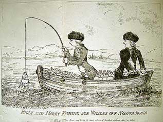
Click here for decription of this rare caricature
SECTION 7 THE DEVIOUS DUBLINER, SEA OTTERS AND THE NOOTKA CONVENTION
The publication of A voyage to the Pacific Ocean.... by Cook and King in 1784, being the narrative of Cook's last voyage, encouraged fur traders of a number of European nations and Americans, to sail to the west coast of America for the profits the book mentioned were to be gained from the pelts of sea otters [Enhydra lutris] and other fur bearing mammals. The Russians had had a thriving business for years, but now faced stiff competition as more traders completed the arduous three-year voyage from Europe and the Eastern United States. Not surprisingly, the animals began to disappear due to over-hunting, and local Indians demanded more in trade goods for the pelts they traded.
The British East India Company [E.I.C.] aka. The Honourable East India Company or ‘John Company’ controlled half the world’s commodity trade and enjoyed a monopoly of trade into mainland China, which posed a problem for British sailors sailing to that country; consequently, many of them sailed and traded under foreign flags.
The first of these trader / explorers who began to explore the coast in detail was James Hanna in 1785, flying a Portuguese flag. While the Russians concentrated their efforts on Kodiak Island, Gulf of Alaska and the Aleutian Islands, Spain at the zenith of its colonial power, attempted to enforce its claim to the remainder of the west coast of America. Don Esteban José Martinez was sent in 1789 to establish sovereignty at Friendly Cove, Nootka Sound (where the Spanish fort San Miguel was built). Upon arrival, he discovered that the British Captain John Meares had already established his own fur trading base there the previous year.
The plunder of Meares’ ship and at least three other ships which were seized by Martinez and the crews arrested (including the ‘North West America’, the first ship built by Europeans in that part of the world) sparked off the "Nootka Controversy".
Public indignation aroused by the British press (the tradition lives on) over the seizure, strained political relations between Britain and Spain to the point of war. However, when France, on the brink of her own revolution, declined to send naval support for its alliance with Spain, the Spanish were forced to reduce tensions in the face of overwhelming British naval power. This resulted in the Second Nootka Convention signed February 1793, whereby Meares would be compensated and the Pacific coast opened to free trade, provided no permanent white settlements were made.
To discuss the Convention terms, the Spanish sent Don Juan Francisco de la Bodega y Quadra and the British, Captain George Vancouver, who had been with Cook on his last voyage as a Midshipman on Discovery (No. 6 built 1744), now captain of HMS Discovery (No. 7 built 1789)1. Between 1792-1795, Vancouver's careful survey of the Pacific coastal inlets, including those of Monterey Bay & San Francisco in which he anchored for victualling, along with those surveys of the Spanish and Americans whom he met on route to Nootka, finally laid to rest the North West Passage theories of De Fonte and De Fuca. He was also a follower and strict adherer to Cook's anti-scurvy and healthy ship environment.
|
 |
|
 |
|
|
|
|
|
 |
|
 |
The numerous place names Vancouver gave, commemorate his work in circumnavigating Vancouver Island and meticulous charting of the coast, in small purpose built boats. He wrote in his journal "that his small boats had been out twenty - three days along the British Columbia coast, travelled seven hundred miles, and yet had surveyed only sixty miles of coastline" 2, during which he preceded Alexander MacKenzie in Dean Channel by only seven weeks.
It was largely due to Vancouver that Britain's claim to the Pacific Coast, resulting in the third Nootka Convention of January 1794 which Spain ceded in 1795, was established. Thus ensuring that it would eventually become part of Canada.4 The accord concluded by Vancouver hosting the first display of fireworks seen in NW America. With Spain out of the picture, trade and exploration was now dominated by the British, Americans and Russians. In the 30 years before settlement of the area, a window in which the shearwater seabird and humpbacked whale thrived amid the nutrient rich traditional waters.
1 There have been eleven ships named HMS Discovery in the Royal Navy, our history sections relate to three: No 6 built 1774 (Cook); No.7 built 1789 (Vancouver); No 10 built 1874 (Nares).
2 & 3 Vancouver Geo, Voyage of discovery to the North Pacific Ocean and around the world …. London 1798
4 The Spanish claims to the Pacific Northwest were acquired by the United States by the Adams-Onís Treaty, signed in 1819. The United States argued that it had acquired a right of exclusive sovereignty from Spain. This position led to a dispute with Britain known as the Oregon boundary dispute. This dispute was not resolved until the signing of the Oregon Treaty in 1846, which divided the disputed territory and established what later became the international boundary between Canada and the United States. Wikipedia
REFERENCES CITED:
Sabin Bibliotheca Americana, A Dictionary of Books relating to America. New York, 1868-1936.
Wagner, H.R. the Cartography of North-West America to the year 1800. Berkley 1937
Cook, A., Holland, C. The Exploration of Northern Canada 500-1920 A chronology. Toronto 1978. 1788, 1789 1791-95.
Morton H. The Wind Commands Univ. of BC. 1975
Vancouver Geo, Voyage of discovery to the North Pacific Ocean and around the world …. London 1798.
Frances Barkley:
Dictionary of Canadian Biography: Barkley, Charles William
|
 |
|
 |
|
|
|
|
|
|
|
|
PLEASE NOTE THAT THESE ITEMS MAY ONLY BE PURCHASED AS A COMPLETE SECTION
Six Items >DOLN PRICE CODE F Contact us
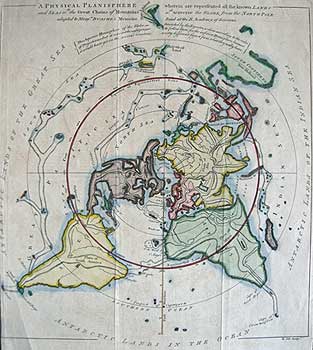
COLE/ BUACHE Planisphere
A PHYSICAL PLANISPHERE wherein are represented all the known lands/ and seas wth the great chains of Mountains wch traverse the globe from the North Pole. /adapated to Monsr. Buache’s Memoire read at the R. Academy of Sciences.
PHILIP BUACHE [London 1757]
Scarce, Copper plate map with original hand colour, on watermark & countermark laid paper
Plate size 13 1/8 x 11 5/8” (33.3 x 29.5cm.) Ref. LRA1172/VS/e.dosv > RLN
Engraved by Benjamin Cole and published in ‘The Gentleman’s Magazine’ March 1757, to illustrate Buache's 3-page essay excerpted from his address to the Royal Academy of Paris. The latter was Buache's seminal work on the N.W. Coast of America and N.E. Coast of Asia. Shows the Sea of the West, Mythical Da Fonte Lakes. Other areas of interest include various pre-Cook notions of world geography conjoined New Guinea and incomplete Australian Coast.
A north polar projection to the Tropic of Cancer, the southernmost landmasses being drawn outside the sphere with the "Antarctic Lands in the Ocean, of the Indian Sea & of the Great Sea." being connected across the Ocean beds.
The body of water, alternatively called the Sea of the West or Baye de l'Ouest, was speculated by Philippe Buache and DeLisle in the early 18th century based upon wishful thinking, American Indian stories, and the somewhat questionable 16th. century explorations of Juan de Fuca. Here Buache gives the Mer de l'Ouest its fullest expression, though he specifically does not connect it to either the factual network of lakes and rivers extending westward from the Hudson Bay or to the speculative De Fonte network just to the north. This map was based on an earlier Buache map first issued in 1752, and illustrates one of the great scientific/cartographic debates between the royal cartographers of England and France.
Philippe Buache 1700-1773 is most respected for his introduction of hachuring as a method from displaying underwater elevation on a two dimensional map surface. He compiled maps based upon geographic knowledge, scholarly research, the journals of contemporary explorers and missionaries, and direct astronomical observation. He was also a great exponent of Speculative geography, which was a genre of mapmaking that evolved in Europe, particularly Paris, in the middle to late 18th century. Cartographers in this genre would fill in unknown areas on their maps with speculations based upon their vast knowledge of cartography, personal geographical theories, and often dubious primary source material gathered by explorers and navigators. The era of speculative cartography effectively ended with the late 18th century explorations of Captain Cook, La Pérouse, and George Vancouver.
|
|
|
|
|
|
|
|
|
 |
|
 |
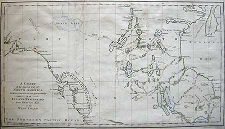
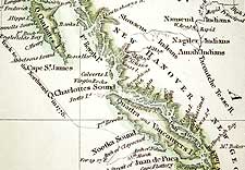
[MEARES]-Western Canada
A CHART /of the interior Part of /NORTH AMERICA DEMONSTRATING the very great probability/ of an/ INLAND NAVIGATION/ from HUDSONS BAY to the WEST COAST.
JOHN HAYWOOD [London 1790]
Hand coloured Copper engraved map on wove paper
9 3/4 x 181/8" (24.8 x45.8 cm.) Ref. LRA846m /dnn/e.dosa > RLN
Published in Capt. John Meares Voyage made in the years 1788 & 89, from China to the North West Coast of America. J.Walter, London 1791-2. Engraved outside the neat-line, bottom left, is “J Haywood, delt St. Martins Church Yard.” and bottom right is ‘Woodman & Mutlow. Sculpt. Rufsel Court,’
This map shows western Canada and the location of the major lakes and rivers known prior to Mackenzie’s expeditions, with the tracks of Samuel Hearne's expedition marked.*
Meares believed that there was an inland low latitude Northwest Passage through the waterways to the vast Slave Lake which was marked on Peter Pond's 1785 map. Despite the presence of the impressive mountain chain, a passage existed supposedly from there, via an as-yet-undiscovered river linking Slave Lake with the Pacific at either Cook's or Turn Again Rivers or Prince William Sound. Also shown are some of the new discoveries along the Pacific coast from Cook’s River to Mt. Olympius (Olympia) –including one of the earliest depictions of Dixon's Entrance (here named Douglas’s entrance), the partial configuration of the Pacific coastline and the erroneous Northern Archipelago (which in reality was part of a misplaced eastern coastline of Vancouver Island.) of the American sloop "[Lady]Washington" (Capt. John Gray), the first American-flagged vessel to round Cape Horn.
Also shown are "Falls said to be the Largest in the known World" to the west of Slave Lake (alas for the tourist industry, completely erroneous.)
Captain John Meares was the devious (some say unscrupulous) Dubliner and proprietor of a fur-trading company operating out of Calcutta, India and Canton, China with a North American base in Nootka Sound. He was also the first to fix the location of the 300 ft. high rock pillar ‘Lot's Wife’: it is now called Sōfu-iwa 孀婦岩 Lat.29°50'N and 140°22'E
Ref: Sabin J. Bibliotheca Americana, A Dictionary of Books relating to America. New York 1868-1936 # 47260
Wagner H.R Cartography of the Northwest Coast of America to the year 1800 Berkeley 1937# 758
Kershaw K. Early Printed Maps of Canada. Ancaster 2002 Vol IV entry 1163 plate 912
Capt. John Meares Voyage made in the years 1788 & 89, from China to the North West Coast of America. J.Walter, London 1791-2
[*vide Section 2]
|
 |
|
 |
|
|
|
|
|
 |
|
 |
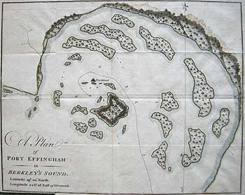
[MEARES/ BARKLEY] Vancouver Island
A PLAN of PORT EFFINGHAM in BERKLEY'S SOUND....Greenwich
[Charles William Barkley] [London 1790 (1791)]
Hand coloured. Copper engraved map on wove paper.
7 3/8 x 9 1/8" (18.7 x 23.2 cm.) Ref. LRA1043m /RL/da.dose > DNN
Published in Capt. John Meares Voyage made in the years 1788 & 89, from China to the North West Coast of America. p.102 J.Walter, London 1791-2. p.172. This delicately hand tinted plan shows part of Barkley Sound on western Vancouver Island, BC., although known to indigenous peoples for centuries.
The sound was charted showing soundings and several small islands, possibly the Broken Group Islands and named by Charles William Barkley and his 17 year old wife, Frances, the first recorded white woman to reach the Pacific coast, in June 1787. She was also the first recorded woman to sail around the world without deception. The sound was charted during the highly successful sea otter fur-trading voyage in the "Imperial Eagle", sailing under an Austrian-Netherlands flag to avoid the E.I.C. monopoly, resulting in a profit of £10,000. The (Berkeley’s) Barkleys are today also credited with the discovery and naming of the Strait of Juan de Fuca which Cook had missed. They then sailed to Calcutta, India, where the Imperial Eagle was confiscated. At the same time, John Meares gained possession of Barkley's nautical gear and his journal. Frances Barkley later wrote that Meares, "with the greatest effrontery, published and claimed the merit of my husband's discoveries therein contained, besides inventing lies of the most revolting nature tending to vilify the person he thus pilfered." Frances, was noted for her adventurous personality and her beautiful long golden-red tresses which, on at least two occasions, saved her life.
Ref. Sabin J. Bibliotheca Americana, A Dictionary of Books relating to America. New York 1868-1936 # 47261
Wagner H.R Cartography of the Northwest Coast of America to the year 1800 Berkeley 1937# 761
Hill B. & Converse C. The Remarkable World of Frances Barkley 1769-1845 ToucjWood editions Surrey BC 2008
Frances Barkley
|
 |
|
 |
|
|
|
|
|
|
|
|
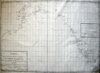
DIXON North West America
CARTE / DES VOYAGES DU KING GEORGE ET / DE LA REINE CHARLOTTE, / aux còtes Nord Ouest de l’Amerique, en 1786 et 1787/dédiée/aux très Honorables Lords-Commissaires de l’Amirauté,/ ….Dixon.
GEORGE DIXON [London 1789]
Copper engraved map on watermarked & countermarked laid paper, French edition
15 3/8 x 23" (39.9 x 58.4 cm.) Ref. LRA1182m /adn/g.dosv > VLN
Published in: Beresford, W. Voyage autour du monde et principalement à la côte nord-ouest de l'Amérique, fait en 1785, 1786, 1787 et 1788: à bord du King-George et de la Queen-Charlotte, par les capitaines Portlock et Dixon (1789) Engraved outside the border, lower left, is “ Gravé par P. F. Tardieu ”
In 1785 Richard Cadman Etches, George Dixon and Nathaniel Portlock formed a trading partnership along with six others, commonly called the King George’s Sound Company, to develop the maritime fur trade in present-day British Columbia and Alaska. In September 1785, Dixon and fellow trader Nathaniel Portlock sailed from England. Both men were graduates of the ‘school of Cook’, (Dixon ca.1755-1800, had been armourer on HMS. Resolution, Portlock master’s mate on HMS Discovery and later Resolution.) Portlock was in command of the larger vessel, the 320-ton King George, with a crew of 59. Dixon commanded the 200 ton Queen Charlotte, with a crew of 33. Dixon and Portlock sailed in tandem for most of their three-year voyage.
In the summers of 1786 and 1787, Dixon explored the shores of present-day British Columbia and southeastern Alaska. He spent the intervening winter in the Hawaiian Islands, where he became the first European to visit the island of Moloka’i. He anchored in Kealakekua Bay where Cook had been killed, but did not come ashore. His chief areas of exploration were the Queen Charlotte Islands (named after his ship) and Sound, Yakutat Bay (Port Mulgrave), Sitka Sound (Norfolk Bay), the Dixon Entrance and Archipelago. While not the first European to explore the region of the Queen Charlotte Islands, he was the first to realize they were islands and not part of the mainland.
|
|
|
|
|
|
|
|
|
 |
|
 |
The two vessels engaged in whaling in the South Seas and sought furs in the Pacific Northwest. They returned to England via Canton, where they picked up cargoes for the British East India Company (EIC). Their voyage accomplished a circumnavigation of the world. After visiting China and selling his cargo, he returned to England in 1788 and published, in 1789, A Voyage Round the World, but More Particularly to the North-West Coast of America. The book was a collection of descriptive letters by William Beresford, his cargo officer and valuable charts and appendices by Dixon. The latter retired from the sea to became a teacher of Navigation at Gosport.
There was a controversy between Dixon and John Meares, another explorer who had published a book claiming credit for discoveries Dixon thought were made by others. This controversy resulted in three pamphlets by Dixon and Meares denouncing each other. In retrospect, history seems to support Dixon's view that Meares was dishonest.
In 1789 Dixon met with Alexander Dalrymple, the Examiner of Sea Journals for the East India Company and an influential advocate of maritime exploration and the Under-Secretary of the Home and Colonial Office, Evan Nepean. He urged on Nepean the need to take up Dalrymple’s plan for a settlement on the North West Coast to prevent the Russians, Americans or Spanish from establishing themselves there. Dixon was afraid that if nothing was done, the coast and its trade would be lost to Britain.
On 20 October 1789, he wrote to Sir Joseph Banks regarding the expedition being fitted out for discovery in the South Seas under the command of his former Discovery shipmate, Lt. Henry Roberts, (yet another protégé) (see section 5). Ironically the Discovery (1789) was to have been Roberts command but was not ready until 1791 and Vancouver got the job by default. Dixon offered suggestions on the type of vessels that would be suitable and proposed the Queen Charlotte Islands as the best place to form a settlement on the North West Coast.
Ref. National Library of Canada G420 B412 1789 fol.
Kershaw K. Early Printed Maps of Canada. Ancaster 2002 Vol. IV entry 1157 plate 906
|
 |
|
 |
|
|
|
|
|
|
|
|
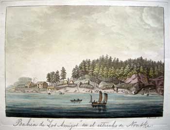
BAHIA DE "LOS AMIGOS' EN EL ESTRECHO DE NOUTKA
PAULO FUMAGALLI [Milan 1820]
Scarce, original colour aquatint
Plate size 7 x 9 ½” (17.7 x 24cm.) Ref. LRA? //g.dosv > DVL
This beautifully coloured aquatint by P. Fumagalli of Friendly Cove, Nootka Sound on Vancouver Island is a scarce, Italian version of the drawing taken on the spot by H. Humphries which was prepared for Vancouver's Voyages,1798. The outpost and stone buildings erected at Nootka Sound during the height of the Nootka Controversy are depicted. To the right can be seen the part of the cove which Spain was prepared to cede to Britain in 1792, which was the subject of the controversy. In the center of the view is shown the wooden cross beneath which lay the sealed bottle, containing the notice proclaiming that part of the coast to be Spanish territory. The title is written, as above, in graphite within the plate mark, beneath the view. Its notation suggests a Spanish ownership of the book from which this plate is extracted, for in the index to Dr. Guilio Ferrario's Il Costume Antico E Moderno O Storia, Milan 1820, this plate (#15) bears the following Italian notation: "Seno Begli Amici Nello Stretto Di Nutka".
The meeting between Spanish envoy Don Juan Francisco de la Bodega y Quadra and the British envoy George Vancouver was very cordial as the two men liked each other and even exchanged copies of the maps they had made. The former prided himself on keeping a fine table, the latter appreciative of a meticulous survey. Both enjoyed the company and hospitality of the native Mowachaht-Muchalaht.
"They (the Mowachaht-Muchalaht) had behaved with a degree of modesty and decorum rarely found amongst men in a far more civilized state... if the conduct they exhibited during the time they passed with us, is to be received as their general national character, it indicates them to be a people unactuated by ambition, jealousy, or avarice. " Geo. Vancouver 3
Although initially no resolution to the controversy was reached, an accord was reached until the third Nootka Convention of January 1794, which settled the matter. Such was the accord between the two men that they decided to name the island upon which Nootka is located Quadra and Vancouver's Island. Later the nomenclature of this large island was shortened to Vancouver Is.
|
|
|
|
|
|
|
|
|
 |
|
 |
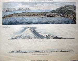
VIEW OF SHELEKOFF’S [sic] ESTABLISHMENT ON THE ISLAND OF KADIAK[sic]
THE NORTH EXTREMITY OF THE ISLAND OF TANAGA BEARING SOUTH DISTANT 15 MILES
ISLAND OF ATCHA [sic] 22 JUNE 1791 BEARING S.E.
S J. NEELE London 1802
Hand coloured copper engraving on wove paper 7 3/8 x 8 7/8” (18.7 x 22.5cm.) Ref. LRAp Arc150 /AN/r.doss > DAL
Three perspective views/recognition profiles on one sheet show the sea otter fur trading community of Grigory Ivanovich Shelekhov (1747-1979), the Russian fur trader and explorer, on the island of Kodiac, Alaska, with its travelling church, astronomical tent and galliots. Tanaga and Atcha (Atka) are islands in the Andreanof and Fox Island group in the Aleutian Island chain. Published in Sauer, M. Account of a Geographic and Astronomic Expedition to the Northern Parts of Russia. London 1802.
Shelekhov organized commercial trips of the merchant ships to the Kuril and Aleutian Islands starting from 1775. In 1783–1786, he led an expedition to the shores of what is now known as Alaska, during which they founded the first permanent Russian settlements in North America. In 1784, Shelekhov arrived in Three Saints Bay on Kodiak Island The indigenous Koniaga, an Alutiiq nation of Alaskan Natives, defended themselves from the Russian party. Shelekhov and his forces massacred hundreds, including women and children, and took hostages to threaten the safety of the other Alaska Natives. Having established his authority on Kodiak Island, Shelekhov founded the first permanent Russian settlement in Alaska.
To purchase the original antique Maps and Prints of section 7 Contact Us
© Darrell G. Leeson MMXVII
|
 |
|
 |
|
|
 |